Metro between stations

metro lengths-system

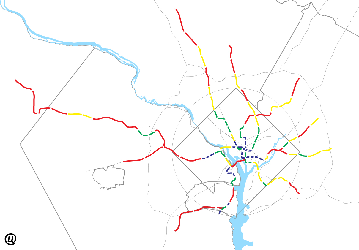
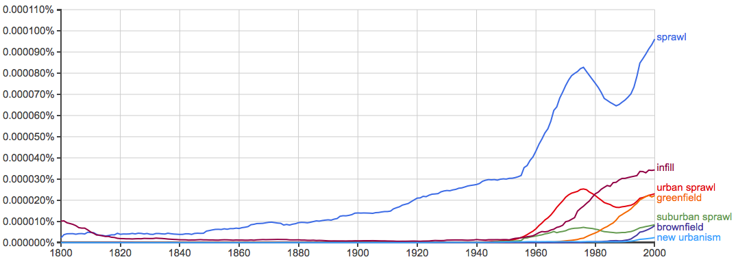
How far apart are Metro’s stations? I think one of the reasons people assume Metro should have express tracks is because the distance between stops varies so much. If you’re a suburban commuter coming in from Franconia-Springfield to Federal Triangle, the long-short-long-short distance must be disorienting. So, even though Metro’s shortest distances barely come close to the New York Subway’s usual local distances.

Matt Johnson has pointed out that Washington’s Metro is a hybrid commuter rail-subway system, most similar to Paris’s RER. With the Silver line opening and the very long gap between Spring Hill Road and Weihle-Reston East, that hybrid nature is only going to get more apparent. The stations in Tysons are fairly close together, but bookended by two of the longest stretches of track.

I wanted to see how this broke down, so with an hour to spare, measured the distances (line-of-sight) between stations. Then I calculated the quartiles and represented them using my base map.

For those railfans out there who will take me to task for erring by inches that I’m less interested in track length than distance between stations. I wanted to look at this from a land-use perspective, not an operations. But, I don’t have ArcGIS, so I don’t have the level of precision Metro’s planning staff has.

Above is what I found visually. Obviously most of the distance is between the longer segments:

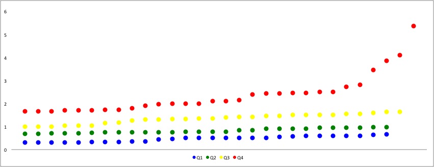
  • Longest Quartile: 66mi, 28 segments, 52% (Red)
  • Upper Quartile: 29mi, 22 segments, 23% (Yellow)
  • Lower Quartile: 20mi, 23 segments, 16% (Green)
  • Shortest Quartile: 11mi, 27 segments, 9% (Blue)

Nothing really groundbreaking, but fun to look at.

length sequence

Since redundancy is so important to transportation design, here is another chart showing how much walkability overlap, in increments of ≤.5mi, ≤1.mi, and too damn far:

metro walkshed overlaps

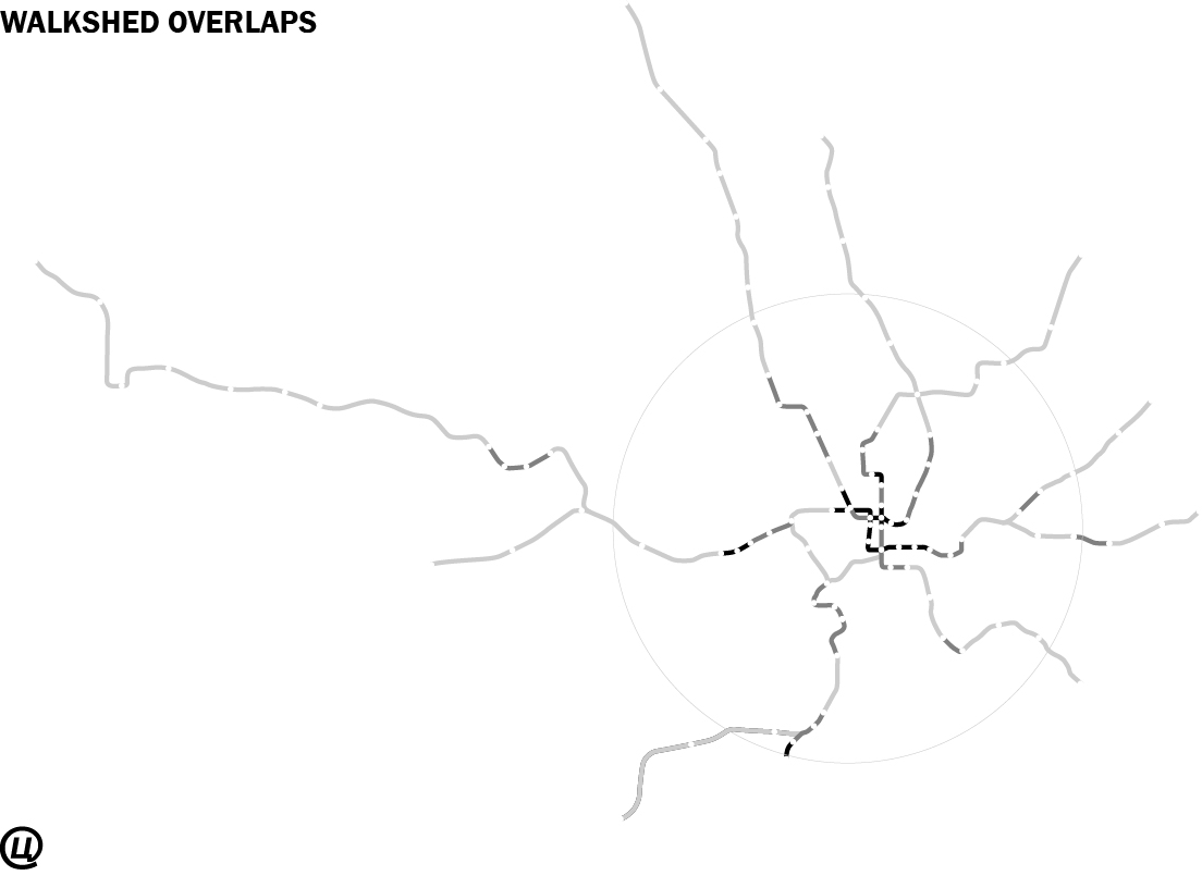
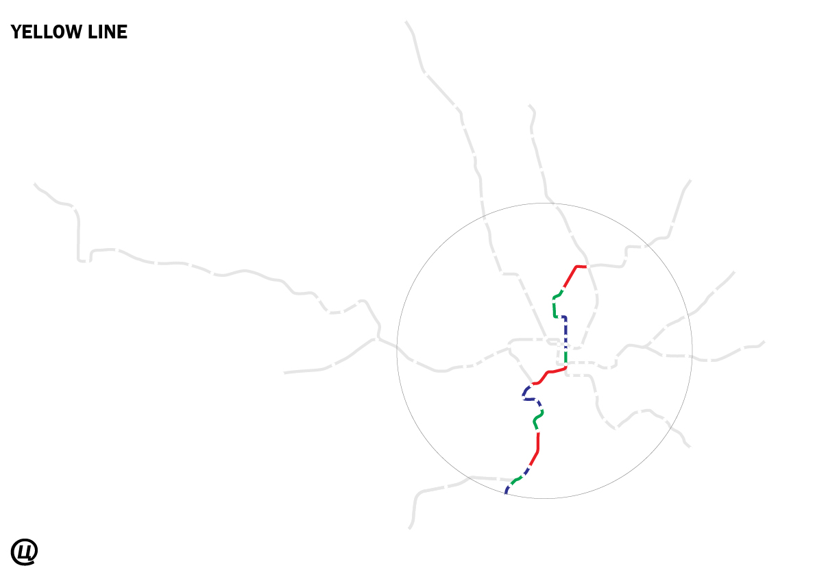
And below, I’ve broken it down line-by-line.

The 1970 study that said DC’s zoning is obsolete

In a post today on Greater Greater Washington, about the third delay of the Zoning Update, David Alpert and I mentioned a report from 1970 that called the 1958 zoning code outdated. 

That was in response to Mayor Gray’s announcement that the Zoning Commission would not close its records until September 2014, so we weren’t able to share as much as I wanted. Here’s more:

Barton-Aschman were hired by the pre-home-rule Walter Washington administration to examine the code after the MLK assassination riots, Urban Renewal, the Metro, and freeway revolt. Not all of their comments were negative, but the technocratic, autocentric attitude that ran through the 1958 process was nowhere to be found. 

These events had big impacts in the ideologies of the planning community. So, just 12 years after the code was passed, they saw a code that was plagued by assumptions that no longer applied and solutions that only seemed to make things worse:

A considerable number of provisions are archaic or substandard and need to be systematically reviewed and modernized. New techniques should be developed to accommodate changing market demand, technological advances, and new social conditions and programs.

Some things changed after this report was published. Parking minimums got lower. Much of the city was downzoned. Overlays were used to make custom tweaks. A more general PUD was introduced. And certain downtown zones became more open to residential uses, making it less of a nighttime wasteland.

Still, some of the ideas these planners found outdated in the Nixon years are still are at the root of the problems the city faces today. 

Is there an anti-Tregoning?

Recently on a few community boards, I’ve seen posts arguing whoever replaces Harriet Tregoning is obviously going to disavow “smart growth.” The problem is: where are they gonna find someone like this?

I’ve never met a professional planner who opposes the policies that constitute smart growth. Give or take a few things, what gets called “smart growth” is the standard approach of almost all urban planners. Despite Tregoning’s involvement in consolidating the agenda of Smart Growth, most of what she supports is the product of 50 years of empirical study of what makes cities work.

Outside of the mainstream, there are socialist and libertarian positions to urban planning. Their positions are significantly more radical than anything OP has proposed.

The topic is worth discussing, because today the Post endorsed Muriel Bowser for Mayor and the Mayor, Vince Gray, appointed Rosalynn Hughey as interim director of the Office of Planning. Whether she becomes permanent or steps down, OP will probably view the city’s problems from the same position Tregoning did.

Gray’s development policies were basically the same ones as Bowser’s mentor, Adrian Fenty. Fenty’s policies were really just versions of Tony Williams’ strategies, developed by Ellen McCarthy and Andy Altman. Tregoning wasn’t that different. She was just more upfront – and willing to be hated.

So there’s little threat that Tregoning’s policies will be rolled back under a revanchist OP. The best the intransigent opponents of development can hope for is spineless. If they truly believe that Tregoning sold out the city to developers, what do they think spineless will do?


When the future was Cleveland PARK

I do love the neon signs, though!

I think a number of people are perplexed as to why Sam’s Park & Shop in Cleveland Park is landmarked. Aside from the political pressure of a well-connected population dead set on preventing the density that would actually save their failing retail strip using historic preservation laws, the site does have some significance.

The Park & Shop was point along the trend to adapt retail architecture to modern conditions. In this page from the May 1932 Architectural Record, the author praised the Park & Shop in contrast to a traditional main street retail strip. He might as well have been describing the service lane block.

If only they'd bulldozed those awful storefronts the strip wouldn't be faltering!

I think a lot of people look back on the beginnings of autocentric planning  and think that the people who conceived it must have been deluded, but to them these choices seem eminently rational. A lot of people also seem to pin the autocentric turn on the Modern Movement and Le Corbusier in particular. This issue of the Record points in another direction: it is unequivocal about the need to redesign retail for the automobile, and merely reports on the International Style as an interesting trend in Europe with good goals.
If anything, Modernism was just a way to aestheticize the rationalist fixations of Modernity like efficiency, objectivity, or hygiene. After all, the first auto-oriented shopping malls were executed in historicist styles. The movement away from urban life began well before that, although Modernists certainly took it further.
It’s a complicated story, one that I don’t really know much about. Luckily, one of my professors, David Smiley, wrote a book about it. Pedestrian Modern, how the desire to accommodate the automobile and pedestrian safely crossed with American modernists’ interest in retail, before 1960s radicalism made that contaminated.
Our Park & Shop comes in towards the beginning of the story.

The Social Media of Small Urban Spaces

In the 1950s, it was a commonplace that urban spaces were inherently antisocial. These days, it’s a commonplace that smartphones are degrading the quality of public interactions. How things have changed!

It took the work of a few people to tease out a more nuanced view of urban life. Rather than looking at the form of cities in drawings, they looked at the people from the ground. These amateurs looked at how inhabitants used space and elaborated from there, rather than starting from ungrounded first principles.

A key player in this movement was William H.Whyte, a journalist by training. When senior editor of Forbes Magazine, he commissioned Jane Jacobs to write some of the articles that catapulted her to fame as a keen observer of public space. Seeing that she had discovered a fundamental flaw in urban planning, he built on her work with the kind of empirical discipline that worked wonders on bureaucrats.

Mostly, he looked for patterns and then examined those patterns in more detail. He used photos, film, charts, timers, and a lot of assistants. I’ve mentioned a film that catalogues his examination Mies’s Seagram Building in New York. Why did this tower in a plaza work, when so many others didn’t?

This kind of empiricism is exhausting, so it hasn’t been replicated much. But the New York Times today ran an article on the work of Keith N. Hampton, a sociologist at Rutgers who has tried to replicate William H. Whyte’s studies of how people use public spaces. With one twist: he was looking at how digital devices are affecting things. 

His results, like Whyte’s, significantly disrupt the conventional wisdom that the diffuse presence of social media are harming our relationships. Not refute, just call into question how idyllic things were before, and whether we’re simply seeing a shift, rather than a decline.

It’s definitely worth your time to read it.

Hampton has some further resources available too, such as his video of Kevin Roche’s steps at the Met, a vintage video from Whyte’s Bryant Park project, and a photoessay showing how people use computers in wifi-enabled parks.


DC HPO says the Tenley Campus is a District

The Historic Preservation Office has released their recommendations for the Tenley Campus ahead of this Thursday, the 27th’s, HPRB hearing. In an unusual decision, they have advised the HPRB to approve the current design, and also to declare the entire campus as a historic district. The Tenleytown Historical Society’s nomination did not ask for an all-encompassing district, but rather a single landmark designation for the entire campus. Their reasoning:

Guidance provided by the National Register suggests that campuses should generally be considered districts, although there are smaller campuses that consist of little more than a central building or two and surrounding space. In the present instance, a district better accommodates the different origins and ages of the major contributing elements of Immaculata, in a manner similar to the often varied neighborhood historic districts.

I find this reasoning plausible at face value. It’s also not unprecedented.  Gallaudet’s campus is a historic district, and Georgetown University may be. The details are more complicated, however. Gallaudet’s district covers much more territory and more historic buildings. Other, similarly sized properties that are not schools have been named landmarks. Indeed, the district only includes three-and-a-half buildings:

The historic district should be designated with the following three buildings considered to contribute to its historic character: the original Immaculata Seminary, i.e., [the 1904] Capital Hall, including its 1921 rear wing; the 1921 Chapel; and Dunblane. The three 1955 buildings should be considered non-contributing, as beyond the campus’s period of significance and representing a phase of school expansion distinctly different architecturally and functionally from the founding era. The 1921 garage should also be considered non-contributing because an addition has considerably altered it and diminished its integrity, nearly doubling its size and closing its original vehicular openings. The sense of clustering campus buildings surrounded by and enclosing landscape, as well as the site’s traditional orientation of, and relationship between, buildings should also be maintained and preserved

Dunblane has been renovated multiple times and burned once. It is unrecognizable from whatever form it may have had. I am fine with leaving a form or mark on the campus, but there is no reason to preserve the building itself if the equally altered garage can go.

I do not necessarily understand why they chose this designation.  I have some conjectures:

  1. It is the result of negotiations between AU and the other parties.  A district designation would most likely preserve the rear green space in perpetuity, but give some design flexibility to AU.
  2. This gives the HPRB more latitude in deciding what happens to the property.
  3. It is easier to justify a district designation than a full landmark designation, given the historic resources.

I do not know the minds of the HPO, but I hope that the reasons for the designation are closely interrogated before the HPRB makes a decision.

As seen in the images, AU recently revised their plans to include a  common area at the front of the building, released a traffic report, and also revealed a much-improved (planometrically) North Hall. Both images courtesy AU. 


In Moscow, a revolution for transportation

Велодорожки МГУ from Alexander Tugunov on Vimeo.

The city of Moscow opened its first on-street bike path in September. It’s a small sign of a strategic change in the urban development of a city that has become legendary for bad traffic.

According to the article, behavior on the trail isn’t perfect: people are parking in the bike path! Unthinkable! But, also unthinkably, the police has promised to enforce the laws and educate drivers. Now, when I lived in Moscow, I saw the city rip up Leningradsky Prospekt to convert it into a highway. That remains unchanged, but now dedicated trolleybus lanes will run along the highway. The entire transportation and land use strategies are being upended because the mayor, Sergei Sobyanin, and the Kremlin have realized that you cannot build yourself out of congestion with still more roads.

If there’s any doubt as to whether this is a token effort, Sobyanin’s comments here and there are explicit commitment to a complete transportation strategy. Take this interview on Lenta.ru:

SOBYANINThe easiest option we could offer is: “Let’s build more roads and interchanges, at two levels, three levels, and, sure, everything will be wonderful.”

Lenta.ru : Yes, like in Tokyo, Beijing and other Asian cities.

SOBYANIN: Yes, but it’s a dead end. It is impossible, even if we had a lot of money. And, there can never be enough money, because the building of highways and interchanges costing absurd sums.

That is just the beginning. There’s trams, trolleys, and a hundred miles of metro construction after the break.

Anacostia foot bridge: a pedestrian idea?

Bob Kerrey Pedestrian Bridge in Omaha/Council Bluffs. Image: Nic221 on flickr.

The bridges over the Potomac, Anacostia, and Rock Creek are very important connections over the strongest boundaries in DC. The relatively few crossings are the bane of commuters and a significant impediment to the development and livability of the DC area. So, it’s no surprise that David Garber has been advocating for a pedestrian bridge across the Anacostia. The most recent iterations have been drawing on the NCPC‘s Extending the Legacy Plan (PDF) and subsequent plans. Plus, there have been a slew of impressive and iconic pedestrian bridges popping up in the US. I think that connecting across the river would be great, but maybe something more than just a fixed link would be best for the Anacostia.

For me, the whiz-bang factor of a bridge is offset by the need for this kind of structure to work as an urban space. Creating a more pleasant route for non-motorized commuters is a good enough end, but for more casual enjoyment, it needs some other qualities. Iconic bridges tend to beautifully express directed motion from one end to another, but not the pauses and distractions of a stroll.

In a way, you create a long pedestrian-only space with no activating buildings. Without a mass of people, those spaces are alienating or unsafe.

There are some relevant examples that approach the concept differently:

AU’s Tenley Campus is Pinned to the Past

American University’s plan for the Washington College of Law not quite right. Designed to minimize conflicts in the short-term, the current plans are not the right kind of development for Tenleytown.

While AU continues to present its east campus plan before the Zoning Commission, they left out plans for the Law School campus at Tenley Circle, promising to submit them in August. But even with that deadline far off, it is possible to tell that the design is wrongheaded. The site is more urban and has more potential than the East Campus site, so it must be held to a higher standard.

Last year, when AU announced a plan to relocate the two blocks from the Tenleytown Metro and at the intersection of Wisconsin and Nebraska Avenues, the potential for progressive campus seemed overwhelming. As at East Campus, political expediency got in the way of good design. The plan is a recapitulation of suburban design principles hemmed in by unwarranted preservation concerns.


Site Plan as of June. Image courtesy AU.

What is good about the design is how it pairs the program to the site. The law school has a non-residential program, where faculty and students live off campus and commute to the school. Many maintain jobs downtown, requiring a direct link into the city, which the metro can provide. Bus lines in eight directions fill in the transit gaps including an express bus on Wisconsin Avenue, which received a TIGER grant for more improvements. It would be very easy to graduate without ever parking a car on local streets.

It is near two functional but underdeveloped commercial strips on Wisconsin Avenue. These have been struggling for years, although most storefronts are occupied as of July 2011. The project could energize the South Tenley and Tenleytown strips by creating a bridge of activity where there is now just a narrow sidewalk and an empty field. The project might add a few customers too, since most students don’t have a meal plan.


Change in lot coverage. Blue areas are new area, yellow is removed, gray is no change. Dark gray represents preserved buildings.

As of July, the designs do not meet of the location’s potential. AU asked the architects, SmithGroup, to mass the building in the footprints of the 1950s campus: objects in relation to each other, but not in relation to the city. As the ground plan has evolved, its forms have become more sophisticated, but its relationship to the streets has remained pinned to the footprints and the outdated ideologies that prescribed them.