Modernity, rushing towards him

July 13th is the 172nd birthday of Otto Wagner. Wagner is one of the first people to use the term “modern architecture,” although his work doesn’t embody the theoretical or stylistic connotations of that term. Nonetheless, he was more than aware of the strangeness of modernity.

wagner stadtbahn viaduct view sm

This rendering, published in the 1897 edition of Moderne Architektur is strikingly dense for what was, at the time, considered the uncultured work of an engineer. Wagner  and his studio produced incredible draftsmanship, but this rendering stands out because of its sheer uncanniness. Look at the two columns. One is stone, safe and solid. The other is cast iron, modern and delicate. A woman works, men turn their backs, and a locomotive of the Weiner Stadtbahn lurks. There are superhuman things and unseen layers to cities, a fact to be made beautiful.

After the break are two more under-appreciated projects of his, one for an asymmetrical bridge over a lock, and the other is the earliest architectural photomontage I am aware of, from 1906.

Designing for DC’s borders

All-singing, all-dancing design giant AECOM is sponsoring a student design contest for urban-scale interventions in cities with complicated relationships to their borders:

This year, we are seeking integrated design, planning, environmental restoration and engineering responses that address border, gateway and edge/fringe conditions in cities worldwide. Proposals should address urban sites currently facing chronic liveability challenges that are largely the result of a city’s location on a physical, political, cultural or economic border.

Now, I bet they’re are talking about urban centers near international borders, because those borders are much more absolute and lead to fascinating instances of disparity and extrastratecraft as business and humanity grind against governmental systems. Nonetheless, given the expectation of feasibility, I see an opportunity for proposals involving DC because its unusual legal condition is so intensified by its small size, unique economy, and structural formation.

Consider the consequences of legislative boundaries around DC: voting rights, income tax losses, diminished school funding, job opportunity, metro funding, etc. Or the geographic limitations of the Potomac, Anacostia, and Rock Creek Park: income distribution, commuting bottlenecks, racial division, and so on. Finally, what about the relationship of DC to the rest of the United States and the world? DC requires the usual things cities import, like food, but it also transfers enormous amounts of wealth, power, and human capital globally. Just because this infrastructure is not physical, does not mean that it does not have physical consequences, e.g. the security duck and  the extensive but inadequate infrastructure.

I suppose that the crises are less severe in DC, but I don’t think design will solve these problems. Instead, the curiousness of Greater Washington’s legal structure can be a much more subtle way of understanding the mechanics of government.

Anacostia foot bridge: a pedestrian idea?

Bob Kerrey Pedestrian Bridge in Omaha/Council Bluffs. Image: Nic221 on flickr.

The bridges over the Potomac, Anacostia, and Rock Creek are very important connections over the strongest boundaries in DC. The relatively few crossings are the bane of commuters and a significant impediment to the development and livability of the DC area. So, it’s no surprise that David Garber has been advocating for a pedestrian bridge across the Anacostia. The most recent iterations have been drawing on the NCPC‘s Extending the Legacy Plan (PDF) and subsequent plans. Plus, there have been a slew of impressive and iconic pedestrian bridges popping up in the US. I think that connecting across the river would be great, but maybe something more than just a fixed link would be best for the Anacostia.

For me, the whiz-bang factor of a bridge is offset by the need for this kind of structure to work as an urban space. Creating a more pleasant route for non-motorized commuters is a good enough end, but for more casual enjoyment, it needs some other qualities. Iconic bridges tend to beautifully express directed motion from one end to another, but not the pauses and distractions of a stroll.

In a way, you create a long pedestrian-only space with no activating buildings. Without a mass of people, those spaces are alienating or unsafe.

There are some relevant examples that approach the concept differently:

United States Bicycle Route 101

br101
br1

Did you know that the United States has signed bicycle routes? You didn’t? Yeah… don’t feel bad, nobody else seems to know about them, and I only stumbled upon them trying to do this month’s Wikiglean. Obscurity notwithstanding, two bike routes do exist and the legal framework is still around – and right now is just the time to breathe life back into the system and make them serious transit.

Back in the 1970s, after the shock of the Oil Crisis, planners – AASHTO even – had the forward idea of determining and assigning interstate bike routes.  Primarily meant for low-traffic roads or dedicated trails, the routes were to connect cities for touring purposes. However, by 1982, only two routes had ever come into being, and so the system went the way of the DMC-12. But conveniently for Washingtonians, the two existing trails currently run through Virginia and one is poised to benefit the Washington Metropolitan area.

Why Design Matters for the Stimulus: Architects

So this is “a few days” late due to some issues with permissions, but here is part two of my argument for design in the stimulus.

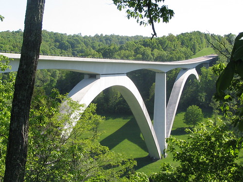
The Natchez Trace Parkway Bridge, by Bretandmarilyn on flickr.
The Natchez Trace Parkway Bridge, courtesy of Brent and MariLynn on flickr.

Unless they are receiving unemployment benefits, the stimulus package is not something that will benefit most architects in any direct way. Mostly consisting of spending for non-physical programs, the ≈$94,000,000,000 that is there for infrastructure and construction is not going to any public projects that conventionally get the high-end architecture treatment. Yet if governments and agencies receive grants for utilities or other community assets and approach these structures with an eye to aesthetics, there is the potential for incredible additions to the fabric of our of towns and cities.

If the average architect wants to get design into these buildings, they’re going to have to look to practice architecture differently than they currently do. Firstly, they need to embrace building information modeling. Secondly, they need to emphasize designing details rather than looking at sophisticated conceptual schemes as justifications for form. Thirdly, architects need to look for different opportunities than what they have conventionally seen as prestige architecture projects.

DC area stimulus projects – Updated!

I’ve updated my map of DC-area stimulus projects to reflect some that were missing last time and added stimulus projects in Montgomery and Prince George’s Counties. I’ll add projects in Arlington, Alexandria, and Fairfax when they are publicly approved.


View DC Area Stimulus Projects in a larger map

DC’s Shovel-Ready Projects

This monday, Mayor Fenty signed and submitted the section 1511 certification to request funds for the first round of highway under the stimulus bill or the ARRA, as the hepcats in the GAO call it. Despite it being for “highway funding” the $57,650,000 will go to eight items that are actually quite urban. Almost every project includes some benefit for pedestrians or the city, and at least two are primarily for them: the Great Streets Initiative project on Pennsylvania Avenue and sidewalk enhancements across the city. Take a look at the projects in the map below, or follow after the break to see a list of projects as well as well as a few proposed ones that didn’t make it. 


View Larger Map

Colorado gets transparency better

After Delaware’s hilarious failure at conveying information, this actually useful Google map from Colorado is refreshing. Since it contains costs, descriptions, ARRA funding, award dates, and completion estimates in a handy visual shell, this has to be the best stimulus site I’ve seen. 

colorado's stimulus funding interfaceIt’s still a lot of semi-imaginary cash thrown at highway construction, which isn’t a good long term allocation for several reasons, but at least they tell us where it’s going with maps…