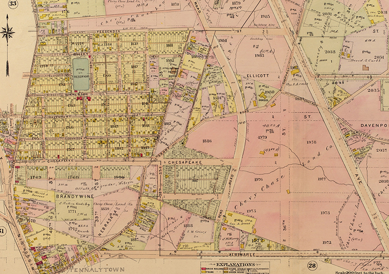
Reno Park Update 100302

This is just an update I think I need to make to make the next recap more clear. When I was working on the locality map, I made some of the decisions based on the principles furthered in Kevin Lynch’s The Image of the City, a crucial text of urban planning.

When he wrote the book, Lynch interviewed a wide array of urbanites to understand how laymen organized, remembered, and navigated their neighborhoods and the city at large. He found that most individuals organized their cities with five archetypal patterns: paths, edges, nodes, districts, and landmarks. One caveat of this induction is that for each person, the definitions vary. The perception of paths depends on a destination and the familiarity with the neighborhood. On the other hand, the designation of edges and districts tends to be more consistent among locals. So, unlike my neighborhood maps, I drew more on personal experience, while also searching for objective measurements.

For example, the paths map (below) is based on the map of locality. The route to a front door might be unique, but there’s an appreciable amount of travel along certain major roads. So, I picked out the bigger paths. I’m willing to bed that most people would see these as frequent routes. Note that this does account for vehicle travel.

paths s

The second element is the edge. Edges form in gaps and hard shifts between building types. Parks and hills constitute much many of the edges unrelated to zoning. These breaks are some of the more prominent physical characteristics in a city, and I believe they encourage neighborhood division like nothing else.

edges s

OK, keep going, there are three more elements…

Read More

Reno Park Update 091212B

So in the last post, I pointed out that it was easiest to demonstrate that some location is a place by showing the density of people there. That’s what this map is. It’s an imprecise but useful tool to map and note the actual behaviors of pedestrians in the T-T area. I’ve made a point of making it blurry and gradated. There are not borders, so much as dips in circulation and public activity that result from the popularity of one area and the amount of effort pedestrians are willing to exert to get from one place to another.

Take, for example, Friendship Heights. Most people arrive by Metro or driving to the retail district. But within only two or blocks of that hub of activity, the circulation patterns change: there are fewer people and they are generally more local. The walkable distance matters more. It’s clear that the locality ends, even if it is slight and gradual.

The character of the architecture changes slightly as one travels south on Wisconsin. It’s shorter, somewhat dinkier. But at Fessenden Street, the entire block is suddenly small, two-story local retail. It looks like little to the north, but also seems slightly different from Tenleytown, up a steep hill to the south. Someone who lived a block to the south would feel like it might be part of Tenleytown, and someone who lives a block to the north might feel it’s Friendship Heights. This is hard to define; just like foot traffic, it comes in gradients. However, due to its higher pedestrian traffic, small public park, and consistent look, I would argue it is effectively a between-place. So let me show you what I’ve come up with:

Read More

Reno Park Update 091125A

Two small additions to the analysis of zoning regulation. First are PUDs. PUD stands for Planned-Unit Development. In a PUD, a developer negotiates with community representatives, offering certain amenities to the public in exchange for some reprieve from aspects of Zoning Codes. There are four PUD structures (in red) here: Van Ness Station, the Saratoga, Friendship Center, and Mazza Galerie.

PUDs

The other major legal framework is the landmarking system. There are a handful of landmarks (red), the Grant Road Historic District (blue), and the not-landmarked-but-sensitive Fort Drive area (yellow). The master plan will have to harmonize with the legal strictures imposed by them.

landmarks

Reno Park Update 091005B

So what is the relationship between zoning and buildings? (Again colors are off!)

zoning-building-forms

Read More

Reno Park Update 091005A

So, property and school districts are both legal structures that have strong effects on the perception of space and the organization of social networks. But generally, the legal structure that affects the commercial and economic growth of spaces is zoning.

zoning-property

Zoning, quickly, is a Progressive-era policy from the early 1900s that dictates what uses can or cannot exist on a certain piece of property or in a general area. The Modern Movement picked up the concept as a way of guaranteeing a healthy city, as did the Garden City and Regional Planning movements. Generally, its effects have been good – like keeping smelting plants away from residences. But it’s also led to unhealthy homogeneity and a commuter culture that was less prominent before governments began micromanaging the fabric of cities.

This is one of the wonkier posts, but it’s important to understand what has been planned for the area. Read More

Reno Park Update 091004B

OK, so the color here is seriously off. I may have to redo some of these maps in a RGB color space. For now, enjoy the eye strain!

I haven’t discussed the role of bicycles in the T-T area, but here’s a map of suitability for bike access. Bear in mind that there are no facilities for bikes, only one designated routes.

bike-routes1

Blue is the one designated bike route that passes near Fort Reno Park, and therefore gives bikers a little more respectability. Green is sidewalks and dark gray is alleys, both places where cyclists have to share the road with pedestrians as well as drivers. Light gray paths represent neighborhood streets with little traffic and generally no center dividing lines. Yellow indicates busier, possibly divided streets where bikers might have some problems with the cars. Red streets are arterials where biking is either dangerous or “disruptive” for automobiles.

That’s it for now.

Reno Park Update 091004A

So, in addition to the visible boundaries of the city, there are the invisible ones, ones that are really only legible to a bureaucracy, but have significant effects on the lives of residents. Because it affects individuals so young and even effects the parents, where someone goes to school seriously alters the social geography of cities. They decide where the majority of socialization occurs: in one school, in another school; in private schools, in public schools; in classrooms or in breakfast nooks.

When I was a wee little Flannie, attending Murch and carousing about my block, I had neighbors across the street whom I hardly knew. Why? They went to Janney. We met and played outside occasionally, but by 3rd grade, we both had already formed our social lives, and that was it. Our parents were likewise divided; they knew each other, but that was it. My street was the boundary between two schools and there was a palpable difference between the facing blocks.

In the Reno-Tenleytown-Tobago area, there are seven schools that provide Nursery school through Twelfth Grade education. Obviously, there’s also American University, but that’s not as relevant since its students are not shaped as much by boundaries and divisions. There are also any number of private and parochial schools students could attend, three of which are in the area, but with a minivan or a Volvo, you too can idle your car outside your child’s school. So let’s just do the public schools.   Read More

Reno Park Update 091003

Now, the final part of contemporary research: pedestrian areas.

all-pedestrian-ways

There are three kinds of areas: unprogrammed spaces like plazas, sidewalks, and walkways, spaces for programmed activities, and then mixed-traffic areas like alleys.
Read More

The Gizorans of Washington and Other Miscellany

I’ve been visiting the Historical Society of Washington and the Washingtoniana collection at MLK library. While I make more sense of my research, here is a pile of interesting things about Upper Northwest:

Famous people have been through the area. Oliver Wendell Holmes was stationed at Fort Reno and referred to the area as “Ten Alley Town.” Dolley Madison watched DC burn from Tenleytown and may have overnighted here. Edward Braddock and George Washington passed through in 1755 on their way to Fort Cumberland, and further east, military failure.

Wisconsin Avenue, from Georgetown to Tenleytown, has been a city street since 1809. But most of the streets were planned after 1897. Some of these schemes were grandiose. For example, in 1901, the city considered tunneling Rock Creek from Adams Morgan to the C&O Canal and building a “parkway” on top. One of the other tunneling proposals put Foundry Branch in a pipe and ran a road to be named Arizona Ave on top of it.

Idaho Ave was supposed to be a much grander thoroughfare before the 1960s, when they gave up on it. It would have intersected Connecticut at Yuma Street. There was supposed to be a circle at Idaho and Reno, north of Tilden. Most shamefully, they dropped a plan to build Hamilton Circle at Idaho and Mass Aves.

Fort Reno Park should have been more developed than it is now. In addition to a Fort Circle plan, the McMillan Commission planned for another parkway up Soapstone Valley and over to Dalecarlia. Until the 30s, Military Road was called Keokuk St. and Grant Road was called Military Road. There was also a Xenia St.

Much weirder stuff below the fold.

methodist-cem

Read More

Reno Park Update 090827

After some awesome long nights, the map of buildings is ready. This was a major hurdle in the project, so expect a slew of posts over the next few days. All I have left are the pedestrian paths, before it’s all analysis and design. So:

all

This is a figure-ground drawing of all the buildings, by use. Keep reading for breakdowns by use. Read More