Arguing the sand from under their homes

The strongest criticism to American University’s East Campus project has come from some neighbors in the adjacent Westover Place private community. Their case against the plan, however, is eroded by a development fight thirty-six years ago, where their own homes were the development threatening to spoil Northwest’s character.

Just as some residents are fighting the potential of AU’s campus expansion, so too did an earlier generation fight the development of the parcels that abut the five-acre parking lot that AU wants to turn into a leafy complex of low-rise residential buildings.

A substantial amount of opposition has arisen in Westover Place, a gated complex of rowhouses between Massachusetts Avenue and Foxhall Road. They have been the most vocal and ANC 3D meetings, insisted that AU build its buildings next to other people’s homes, and it was the meeting point of this summer’s traffic protest.

But in 1977, it was the threat of Westover Place that was vexing locals. According to a September 25th, 1977 Washington Post article: “And to the north of this, adjacent to the 5-acre university parking lot, Kettler Brothers Inc., the giant development company that built Montgomery Village, has already cleared more than eight acres where 149 town houses will be constructed. Houses in this development, Westover Place, will sell from about $135,000.”

In the article, entitled “Bulldozers at the Estates,” Phil McCombs reports on arguments and characters not unlike the current fights over American University’s expansion and other developments in the area. Just as before, opponents are appealing to a right of first arrival, but the article lays bare the hypocrisy in living in a development while fighting a development because it will have the same effects your house did. The rowhouses of Westover Place and similar developments paved over Northwest’s last open spaces that seemed so essential to the “rural” character of piedmont Washington.

Similarly to the opposition to the 1960 Tenley Library and the 1941 Sears Roebuck, an enormous to-do was made over the development and yet both became established elements of the community. At that time, however, the changes seemed signified the end of something unique. McCombs quotes the ANC3 Commissioner Polly Shackelton bemoaning the change:

“Here you have these fine established residential neighborhoods, which will be impacted with increased density and traffic and all kinds of things that really could be very damaging,” she said. “I think in a way it’s too bad we don’t have a comprehensive plan.”

She said that development of the Rockefeller estate, for example, “will be devastating because Foxhall Road is already crowded. With 100 new houses there, I don’t know how we’ll deal with it.”

The problematic idea here is “establishment:” that because a neighborhood has reached any level of development, it should be maintained as it is. Are the current residents who now enjoy this property more justified than their neighbors who lived there in 1977, or estate owners who lived there in 1917?

Don’t Just Preserve History at Tenley Campus, Interpret It.

With a more creative approach to preservation, American University’s plan for its Tenley Campus could produce better urban design and a more compelling presentation of the site’s history.

Capital Hall and its lawn. Image: Wikipedia.

AU has agreed to preserve several structures on the site: the a former farmhouse called Dunblane House, Capital Hall the main building visible from Tenley Circle, and a Chapel. Together, these buildings form an axis that the Historic Preservation Office has insisted on preserving.

The Historic Preservation Office is right to emphasize this axis; it is probably the most interesting part of the site. The architects at SmithGroup have worked within these requirements to create a private quadrangle between the old house and Capital Hall, which looks good so far.

But AU has also decided to build on the footprints of the existing 1950s buildings and not construct anything that would obscure Capital Hall. The buildings are preserved, but no part of the campus will feel different from the others, even if they are in a slightly different style. The new buildings offer no key to understand on the site they inherit.


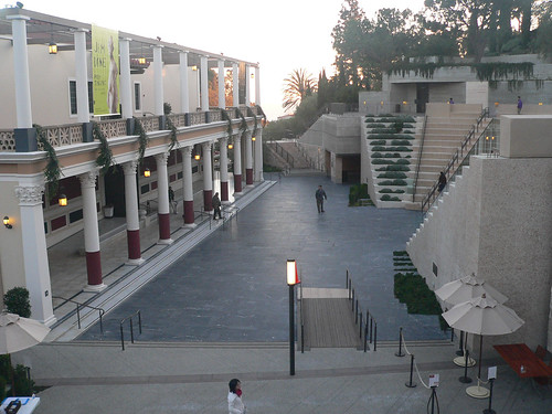
An abstracted amphitheater frames the Getty Villa. Image: The Consortium/Flickr

To understand what I mean by interpretation, take a look at Machado & Silvetti’s renovation of the Getty Villa. They combined the pragmatic need for an an entry stairway with architectural promenade that helps visitors understand the museum’s curatorial approach. Treating the 1970s replica of a roman villa as an object in a collection, stairs and pathways frame the building in a sequence that calls to mind an excavation. The stair gives visitors a lens with which to understand the building and clears their minds of the drive out to Malibu.

American’s Unexceptionalism

While American University’s campus plan is a net benefit for Ward 3, the architecture currently proposed for the campus is mediocre at best. Beyond the land-use planning, East Campus and North Hall’s proposed buildings offer little in terms of aesthetics. The spaces are disorganized and the forms are uninspiring. On the outside, the buildings don’t relate the street well, and the facades present foggy contextualism.

Instead of well-executed buildings, the design revolves around appeasing neighbors while important aspects are left undeveloped.

For East Campus and some of the Main Campus buildings, AU hired Little Diversified Architectural Consulting, a Charlotte-based firm with offices in Alexandria. They have designed a large dorm at Catholic University, Opus Hall, similar in style and form to AU’s proposed facilities. Other design work was executed by the university’s large in-house architectural group and the firm of McKissack & McKissack.

“Stop AU” Protest Tomorrow, Parking Provided

Westover Place residents will be protesting the presence of pedestrians at Ward circle Thursday morning during rush hour. But I don’t want to speak for them. Here’s the call to arms they left on the AU Park Listserv:

TRAFFIC IMPACT DEMONSTRATION

A coalition of neighbors surrounding American University will be gathering
together this Thursday morning, May 26th from 8:30 am to 9:00 am to walk around
Ward Circle, crossing Massachusetts and Nebraska Avenues several times to
physically demonstrate the impact 600 or 700 students will have on traffic, if
AU puts the number of beds it wants on the Nebraska Avenue parking lot.

Almost 21,000 vehicles use Mass. Ave. daily and about 24,500 use Nebraska. And
yet, AU’s flawed traffic study, which they are presenting to the Zoning Office
to get approval for their beds, claims that adding to the pedestrian traffic
load will have no impact on traffic at the circle.

Help us show the city AU is wrong.

If we can get a large number of residents to walk around the circle several
times, wearing buttons that say “Stop the AU Campus Plan” and have a couple
more stationed on the sidewalk with signs that say “AU Plan Causes Gridlock”
“Honk if You Hate Gridlock” and put large “Stop the AU Campus Plan” in the
center of the Circle, our case will be self evident. Everyone will see
firsthand the traffic gridlock and noise pollution that will result if AU gets
its way.

We need your commitment now. Join with your friends and neighbors to really do
something to get our plight noticed and have a little fun. We’re not just paying
lawyers to make studied arguments. We’re standing up for ourselves and using
our feet to fight for our neighborhoods!

We’re meeting just inside the gate of Westover Place, in the front courtyard of
4300 Massachusetts Ave, behind the guardhouse at 8:30 Pick up your buttons and
those of you who want signs can get them. Then we’ll go up to the Circle and
cross the street.

The guard at the gate will be alerted. Secret Code is “Stop AU”. There are
several guest parking spaces behind the Mass. Ave. wall which will work if we
all carpool.

Yep, the issues here do seem pretty self evident. So, if you’re in the area, think about talking to the poor folks. But just do mind to not inconvenience drivers. It’s their street.

Reno Park Update 091005A: Zoning Definitions

So, property and school districts are both legal structures that have strong effects on the perception of space and the organization of social networks. But generally, the legal structure that affects the commercial and economic growth of spaces is zoning.

zoning-property

Zoning, quickly, is a Progressive-era policy from the early 1900s that dictates what uses can or cannot exist on a certain piece of property or in a general area. The Modern Movement picked up the concept as a way of guaranteeing a healthy city, as did the Garden City and Regional Planning movements. Generally, its effects have been good – like keeping smelting plants away from residences. But it’s also led to unhealthy homogeneity and a commuter culture that was less prominent before governments began micromanaging the fabric of cities.

This is one of the wonkier posts, but it’s important to understand what has been planned for the area.

Reno Park Update 091004B: Bike Routes

OK, so the color here is seriously off. I may have to redo some of these maps in a RGB color space. For now, enjoy the eye strain!

I haven’t discussed the role of bicycles in the T-T area, but here’s a map of suitability for bike access. Bear in mind that there are no facilities for bikes, only one designated routes.

bike-routes1

Blue is the one designated bike route that passes near Fort Reno Park, and therefore gives bikers a little more respectability. Green is sidewalks and dark gray is alleys, both places where cyclists have to share the road with pedestrians as well as drivers. Light gray paths represent neighborhood streets with little traffic and generally no center dividing lines. Yellow indicates busier, possibly divided streets where bikers might have some problems with the cars. Red streets are arterials where biking is either dangerous or “disruptive” for automobiles.

That’s it for now.

Reno Park Update 091004A: Schools

So, in addition to the visible boundaries of the city, there are the invisible ones, ones that are really only legible to a bureaucracy, but have significant effects on the lives of residents. Because it affects individuals so young and even effects the parents, where someone goes to school seriously alters the social geography of cities. They decide where the majority of socialization occurs: in one school, in another school; in private schools, in public schools; in classrooms or in breakfast nooks.

When I was a wee little Flannie, attending Murch and carousing about my block, I had neighbors across the street whom I hardly knew. Why? They went to Janney. We met and played outside occasionally, but by 3rd grade, we both had already formed our social lives, and that was it. Our parents were likewise divided; they knew each other, but that was it. My street was the boundary between two schools and there was a palpable difference between the facing blocks.

In the Reno-Tenleytown-Tobago area, there are seven schools that provide Nursery school through Twelfth Grade education. Obviously, there’s also American University, but that’s not as relevant since its students are not shaped as much by boundaries and divisions. There are also any number of private and parochial schools students could attend, three of which are in the area, but with a minivan or a Volvo, you too can idle your car outside your child’s school. So let’s just do the public schools.  

Reno Park Update 091003: Walkspace

Now, the final part of contemporary research: pedestrian areas.

all-pedestrian-ways

There are three kinds of areas: unprogrammed spaces like plazas, sidewalks, and walkways, spaces for programmed activities, and then mixed-traffic areas like alleys.

Reno Park Update 090827: Uses

After some awesome long nights, the map of buildings is ready. This was a major hurdle in the project, so expect a slew of posts over the next few days. All I have left are the pedestrian paths, before it’s all analysis and design. So:

all

This is a figure-ground drawing of all the buildings, by use. Keep reading for breakdowns by use.