When the future was Cleveland PARK

I do love the neon signs, though!

I think a number of people are perplexed as to why Sam’s Park & Shop in Cleveland Park is landmarked. Aside from the political pressure of a well-connected population dead set on preventing the density that would actually save their failing retail strip using historic preservation laws, the site does have some significance.

The Park & Shop was point along the trend to adapt retail architecture to modern conditions. In this page from the May 1932 Architectural Record, the author praised the Park & Shop in contrast to a traditional main street retail strip. He might as well have been describing the service lane block.

If only they'd bulldozed those awful storefronts the strip wouldn't be faltering!

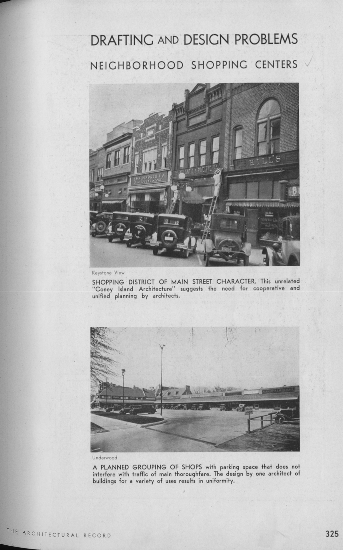
I think a lot of people look back on the beginnings of autocentric planning  and think that the people who conceived it must have been deluded, but to them these choices seem eminently rational. A lot of people also seem to pin the autocentric turn on the Modern Movement and Le Corbusier in particular. This issue of the Record points in another direction: it is unequivocal about the need to redesign retail for the automobile, and merely reports on the International Style as an interesting trend in Europe with good goals.
If anything, Modernism was just a way to aestheticize the rationalist fixations of Modernity like efficiency, objectivity, or hygiene. After all, the first auto-oriented shopping malls were executed in historicist styles. The movement away from urban life began well before that, although Modernists certainly took it further.
It’s a complicated story, one that I don’t really know much about. Luckily, one of my professors, David Smiley, wrote a book about it. Pedestrian Modern, how the desire to accommodate the automobile and pedestrian safely crossed with American modernists’ interest in retail, before 1960s radicalism made that contaminated.
Our Park & Shop comes in towards the beginning of the story.

Sidwell’s Machine for Environmentalism

Rain garden with wetlands in rear.

Landscape-oriented architecture blog Pruned is carrying an excellent post about the wastewater-recovering wetland installed at the center of their new campus. The LEED Platinum building, which opened in 2007, was designed by KieranTimberlake of Philadelphia. The firm designed the building to recycle all of its graywater and brownwater through an elaborate wetland, as one of its many sustainable features. If you go visit the building, the trickle filter is wrapped with a sign that explains how the system works. The sign rests at a child’s height and leads readers around and around with arrows, which I find a little obnoxious. Luckily, Pruned has explained the process more clearly, so without further ado, go read their article

Pruned also notes a very important civic issue this solves: the cost of runoff on municipalities and local watersheds. This beautiful oasis reduces the amount of water that flows out of the building, or flows off the hard surfaces of the building (there is a separate rainwater recycling system), and into Rock Creek and the White Plains treatment facility. Among the general public, a lot is made of water conservation (which this building also assists), but the strain on public facilities caused by sewage and stormwater is quite severe. At least up in Cleveland Park and Tobago, we do not have combined sewer overflow systems, like the do downtown. 

For elite Washingtonians worried that their children will become astronauts or mutant mer-men, the recycled water is dyed blue with a non-toxic coloring agent and reused in toilets and janitorial sinks. Meanwhile, St. Albans School’s non-LEED Marriott Hall, by SOM is in the interior-fit out phase, and has just gained its green roofs. More on that some other time.

Fort Reno project 090424: Topography

So I want to study the park with as much detail as possible. I’ve been spending a lot of time there just observing, which is always the cornerstone of good design, but I’ve also been trying to understand the area objectively. Logically, the place to start is with the ground, so here is a topographic map I’ve put together.

s-topomap
Topographic maps represent altitude using lines called contours. The closer contours are to each other, the steeper the slope, the further, the flatter. The contours start here at 62m and end at 130m.

After the fold, there are other, cooler maps that show height using shading.